Shaping a community-centered pedestrian and bike path through West Oakland
The West Oakland Link is a proposed 1.1-mile-long, elevated pedestrian and bicycle pathway intended to safely connect West Oakland to the Bay Skyway/Bay Bridge Trail and the Port. Through a series of collaborative meetings, local outreach, and working directly with the agencies involved, WOEIP is ensuring that the West Oakland community plays a meaningful role in shaping this important transportation project in our neighborhood.
Throughout the project’s design and engineering phase, WOEIP hosted a series of Community Planning Sessions and provided a feedback loop for West Oakland residents to engage directly with project planners and designers.
Jump to…
Explore the designs
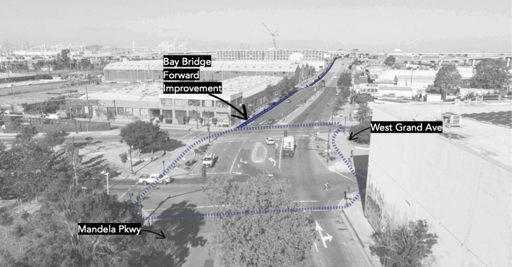
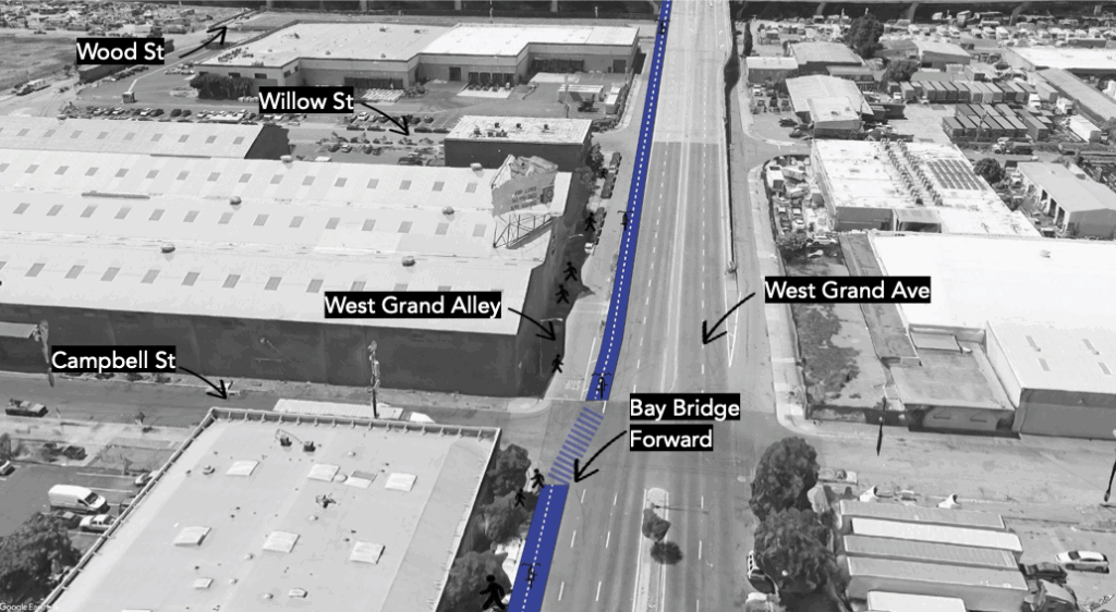
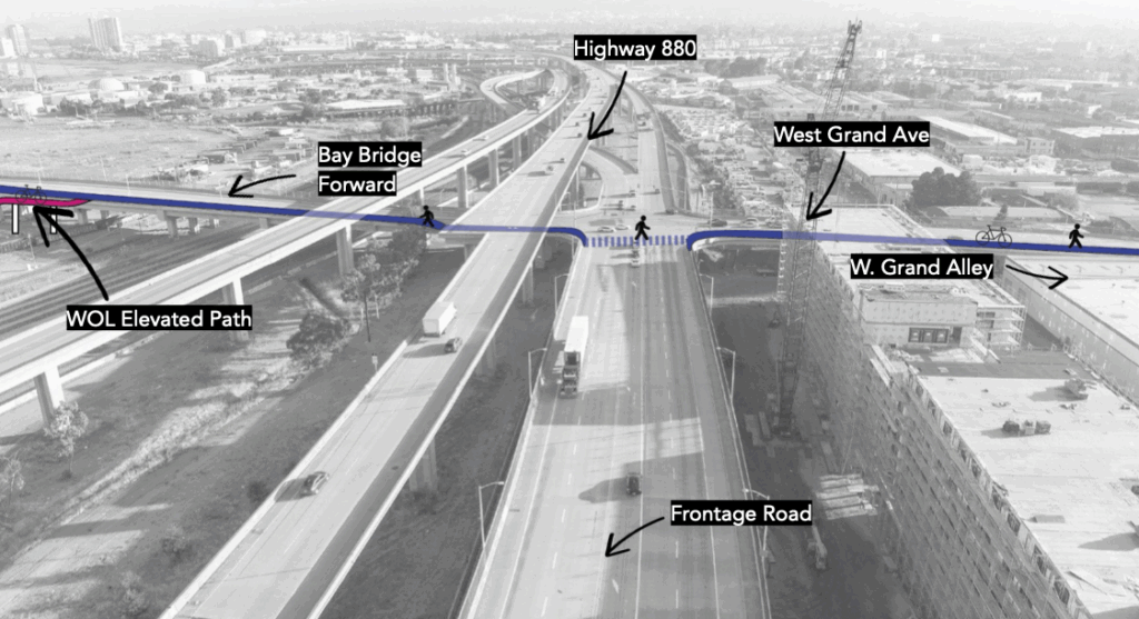
The West Oakland Link will be built in two phases. The first phase will deliver the interim Bay Bridge Forward Path connecting Mandela Parkway and Maritime Street in 2027 and an elevated bike and walk path west of Frontage Road down to the Bay Trail/East Span Path in 2029. The project team will continue to seek funding to complete Phase 2, which is expected to be completed in 2031. Phase 2 will deliver a path through the residential neighborhood between Frontage Road and Mandela Parkway.
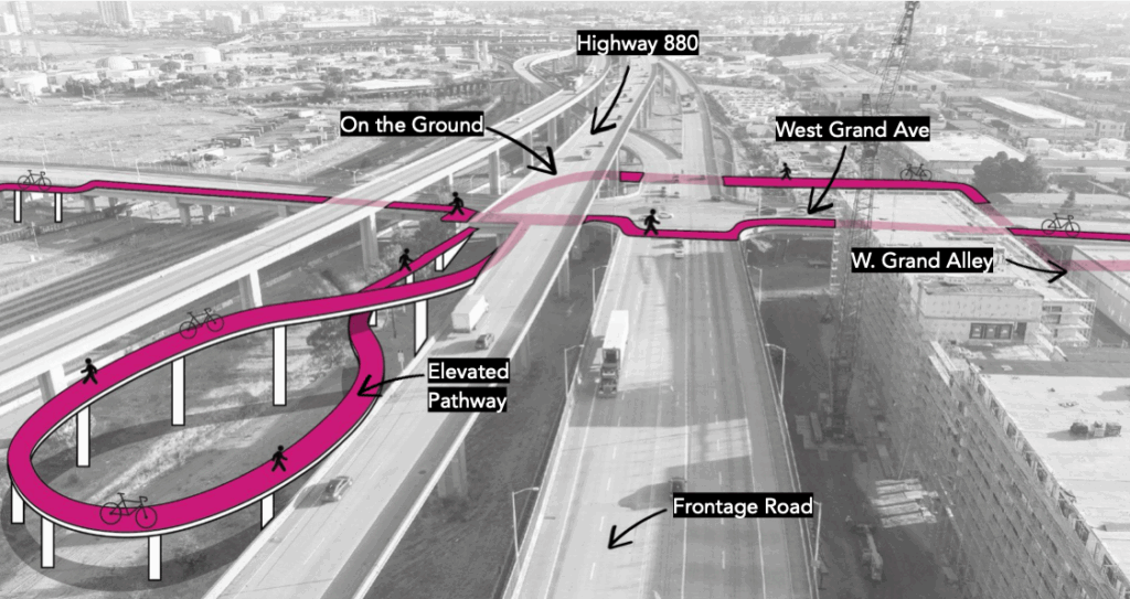
Phase 1: An elevated pathway over the Port
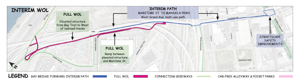
The first phase of construction will create an elevated path over the Port. The path will leverage Bay Bridge Forward, another MTC program that will expand HOV and bus lanes and add a temporary multiuse path along West Grand Ave. Together, the elevated structure over the Port and the path along West Grand will give people a safe connection from the Bay Trail to existing paths at Mandela Parkway.
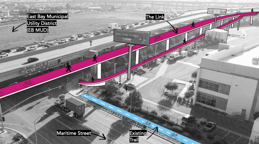
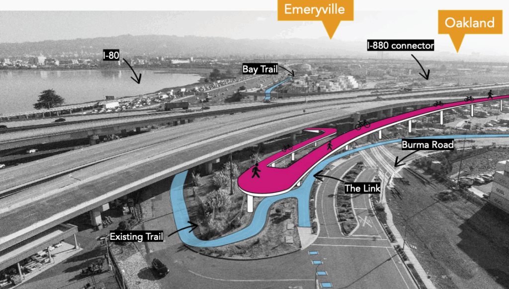
Graphics produced by Einwiller Kuehl, Landscape Architect.
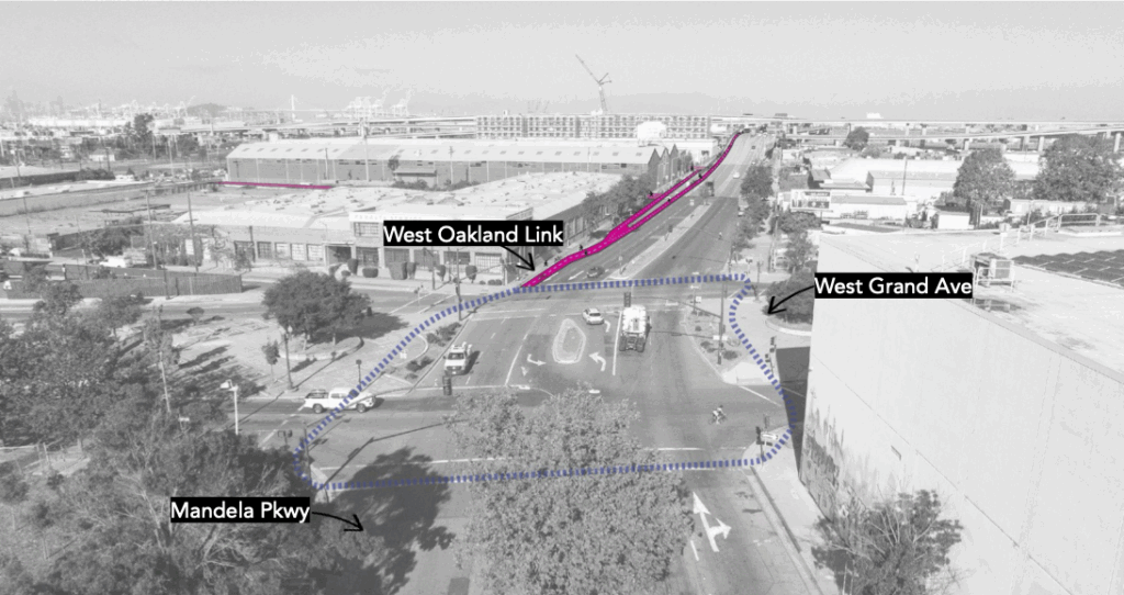
Phase 2: Pocket parks, car-free spaces, and amenities between Mandela Parkway and the railroad tracks
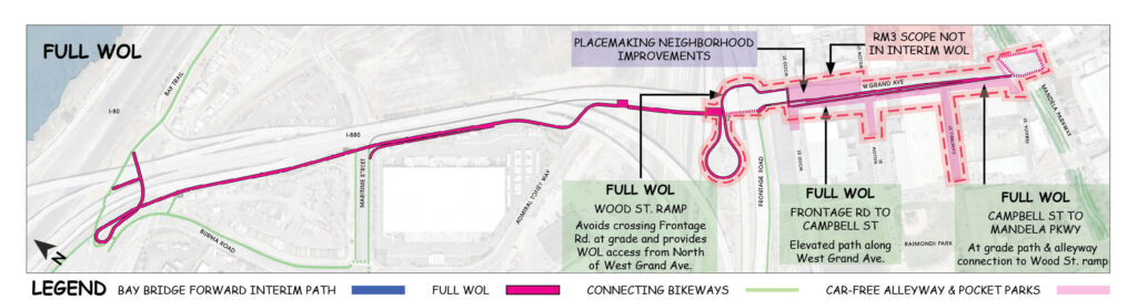
Phase 2 will replace the temporary Bay Bridge Forward path with a wider path. This is the stage that will incorporate proposed amenities like car-free alleyways and pocket parks between Wood St and Mandela Parkway. Phase 2 will also replace the crossing at West Grand Ave and Frontage Road with a loop to bring people between the elevated and ground-level sections of the path.
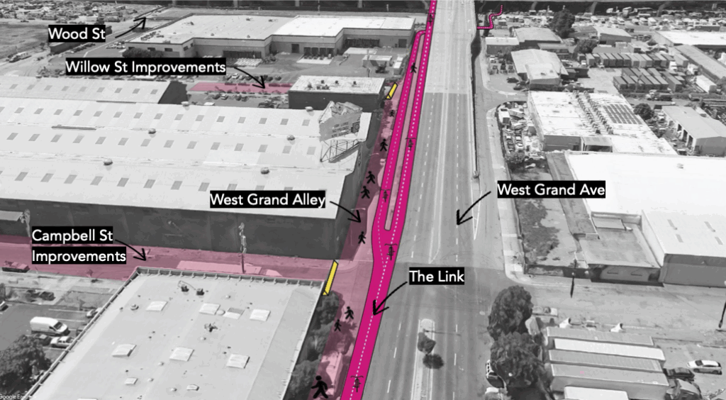
Graphics produced by Einwiller Kuehl, Landscape Architect.
Watch the latest community presentation
Community feedback ⇩
WOEIP and MTC hosted a series of design sessions with the community to gather ideas and feedback that will inform the final design of the project. This participatory process surfaced some consistent themes that continue to evolve as the community weighs in.
Review early feedback (PDF)
A desire to minimize air pollution exposure from vehicle exhaust coming from the freeways and roads adjacent to the Link’s path.
Concerns about the safety of isolated areas, with calls for good lighting, visibility, and maintenance.
A call for effective signage and environmental design that aids wayfinding and spotlights the location’s unique history and circumstances.
Insistence that the path be accessible to those with mobility limitations.
Reminders that some West Oaklanders depend on auto transit through the area.
A desire to reduce noise pollution from adjacent roadways.
About the West Oakland Link
Planning for the West Oakland Link began a decade ago, in an effort to create
a safe path for pedestrians and cyclists to travel between West Oakland’s residential
neighborhoods and the Bay Bridge Trail, Treasure Island, and downtown San
Francisco. The project is now in the design phase, with construction on Phase 1 expected to be completed in 2029.
Who is responsible for the project?
The West Oakland Link project is managed by the Metropolitan Transportation Commission and Bay Area Toll Authority.
What is the project timeline?
How much will it cost and who is paying for it?
This project is projected to cost $100 million. The Bay Area Toll Authority, Alameda County Transportation Commission, the City of Oakland, and Caltrans have allocated $63 million, which will cover the first phase of the project. The project team is pursuing transportation grants from State and local sources to cover the remaining cost to fund construction fully.
What are the potential environmental impacts of the West Oakland Link?
According to project planners, “impacts would come primarily from construction, with recommended mitigations ranging from dust control to appropriate disposal of hazardous materials encountered during soil excavation.” Read MTC’s full impact analysis.
Can the funding for this project be spent on other things instead?
The money earmarked for the West Oakland Link is specifically allocated for infrastructure and transportation projects, and cannot be reallocated to other investments.
Who will be responsible for maintaining the path once it’s built?
Maintenance for the elevated portions of the Link will be funded by the Bay Area Toll Authority, and carried out by CalTrans. Ground-level portions of the trail require an alternative maintenance strategy, which is currently being developed by Bay Area Toll Authority staff.
Have other locations for the path been explored?
Early in the project’s planning days, several routes were explored. This route was selected by the community at the time, and includes land that is largely owned by CalTrans and the City of Oakland. The Seventh Street path will connect with the West Oakland Link via the Maritime Street path and will provide an alternative route for residents of West Oakland to use the Link.
Want to know more?
For project details or to get involved, email Nicole Merino Tsui.
Community engagement funding for this effort is provided by: